Attending a club trail ride is a very comfortable experience. We have a trail leader that has taken all of the responsibility for knowing where we are going and how to get us back. Ahh, we can all just follow along and enjoy the scenery and/or the challenge of obstacles along the trail. Have you ever thought that you would like to revisit the area sometime on your own? Lets think about how we could figure out how to retrace these steps as a leader a month or two later.
Maybe it would be a good idea to record the path taken with a GPS receiver. Global Positioning System, or GPS, devices are wonderful instruments. They allow you to pinpoint your location to within a few yards, no matter where you are on planet Earth! How about looking at the scenery for landmarks that you can remember? Another thing to think about is looking at the trail itself. How well traveled is it? How does the apparent traffic level of the trail that you are on compare to other trails that take off from it? Oh, I know, let's mark a waypoint at each intersection where we would have to make a decision the next time we come. On top of that, I'll note the name of the waypoint and record something like "left turn at the Y with the rock that looks like a dog on the right." I think that I will even take a picture of the intersection with my digital camera. That way, I could use it and my GPS data to create myself a trail guide when I lead a trip the next time.
GPS receivers are great fun, they are very useful tools, and they are easily obtained at reasonable cost. In fact, you probably already have one that is built into your smartphone. But be careful! Don't rely on a GPS until you first prepare yourself with the knowledge and skills required to find your way with simple tools like a map and compass. Map reading and navigational skills are developed by practice. I would suggest buying maps of any area that you might be interested in returning to on your own or as a leader. (On your own meaning in a small group, never wheel alone.) It is easiest to read a map if the map is oriented to the surrounding landscape. If you see a valley on your left, then the valley shows on the left on the map. You can do this by eye or with a compass. Lay the map on the ground or hold it horizontally. Rotate the map until recognized features on the ground roughly align with those on the map. With the map oriented, look around for prominent features such as mountains, valleys, lakes, rivers, etc. Make a mental note of the geographical features you will be traveling along and seeing during the day. If you keep the terrain in your mind, you will usually have a general idea of where you are just by looking around.
Topographic maps can be particularly useful to help orient using the surrounding landscape. Topo maps utilize contour lines to depict the 3-dimensional character of the terrain on a 2-dimensional map. Contour lines drawn on the map represent equal points of height above sea level. On multi-colored maps, contour lines are generally represented in brown. The map legend will indicate the contour interval-the distance in feet (meters, etc.) between each contour line. There will be heavier contour lines every 4th or 5th contour line that are labeled with the height above sea level.
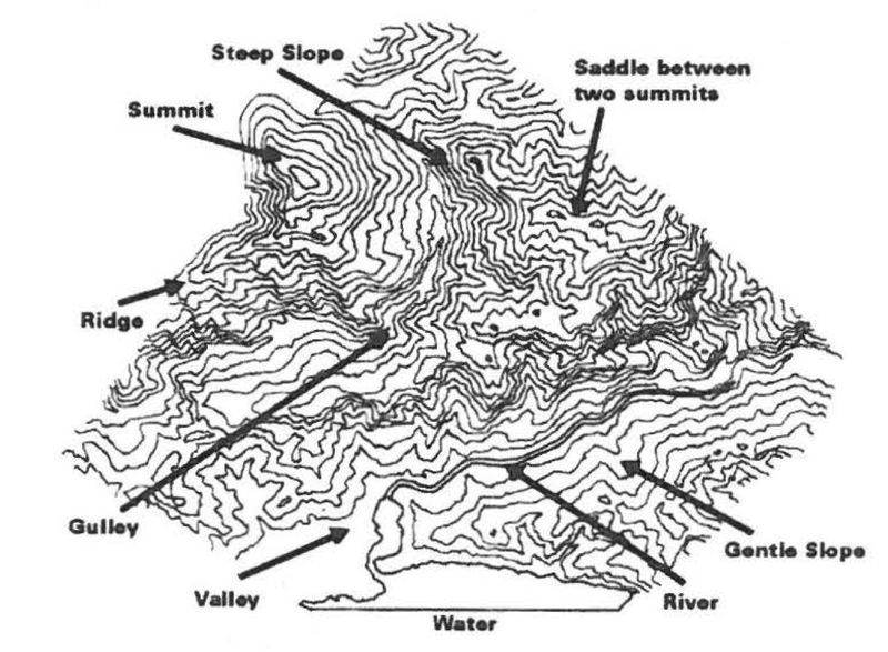
Drawn Contour Lines
- Steep slopes - contours are closely spaced.
- Gentle slopes - contours are less closely spaced.
- Valleys - contours form a V -shape pointing up the hill - these V's are always an indication of a drainage path which could also be a stream or river.
- Ridges - contours form a V -shape pointing down the hill.
- Summits- contours forming circles.
- Depressions - are indicated by circular contour with lines radiating to the center.
A topographic map, by itself, isn't much good if you can't point to where you are on it. Similarly, a GPS unit isn't worth much unless you can read the coordinates of your location and then find that place on the map. That's happiness. Here's me . . . there's the river ... there are these two hills ... there's where I want to go. Most maps display latitude and longitude at the edges which can be used with GPS data in order to determine your location on it. Get used to working from map to GPS and GPS to map-with a little compass work thrown in for good (safety) measure and you're a 4x4 Navigator.
NMOHVA's Ride New Mexico Page
The New Mexico Off Highway Vehicle Alliance (NMOHVA) provides this central webpage where the public can download all US Forest Service Motor Vehicle Use Maps (MVUM) for National Forests and Grasslands located in New Mexico. NMOHVA has made the MVUMs “smarter” by making sure they all have geospatial information (the map knows where it’s located in the World) and by providing them in multiple formats.
USFS Interactive Visitor Map
The United Stated Forest Service (USFS) provides an interactive visitor map. The Interactive Visitor Map is intended to depict physical features as they generally appear on the ground and are not intended to be used to determine title, ownership, legal boundaries, legal jurisdiction, including jurisdiction over roads or trails, or access restrictions that may be in place on either public or private land. Obtain permission before entering private lands, and check with appropriate government offices for restrictions that may apply to public lands.
Top BLM Motorized Recreational Opportunities Interactive Map
The BLM's Top Recreation Opportunities Mapping Series is designed to provide and promote a greater awareness of recreational opportunities on BLM-managed public lands. The BLM partnered with the National Off-Highway Vehicle Conservation Council (NOHVCC) to highlight some of the BLM's highest quality motorized recreation opportunities across the nation. Users can now find information to plan their next exciting ride while at home or on the road. Using an interactive web-based storymap, users can get familiar with recreation site amenities, season of use dates, camping availability, and more.
Georeferenced PDF Maps from the BLM
Heading out for a remote adventure? No cell coverage? No problem. The BLM has developed georeferenced maps compatible with any georeferenced map mobile application. Click Here for more information.
![]()
If you wish to convert GPS files from one format to another, such as GPX to KMZ, GPS Visualizer works quite well. [GPS Visualizer is not part of the NM4W site.]
 Use Avenza Maps® on your mobile devices to locate yourself without the Internet or network connections. Use your device’s built-in GPS to stay safe, on track, on the trail, and aware of where you are on any map, even in the most remote places. A great feature of this free app is the fact that it doesn’t have any advertisements. The reason that this app is useful is that many of the USFS Motor Vehicle Usage Maps (MVUMs) are available for free download. This app enables the user to display the MVUM on the screen of the device and utilize the GPS to display your actual location real-time. Since the MVUMs only display the routes that are open, this is an extremely useful tool to help one stay on the legal routes. There are many roads on the ground in the forest and the most pronounced road is not always the one that has been designated as open. For example, FR656 in the Jemez appears to end in two places when in fact, the road continues on beyond the designated “end”. Without an app like this in your toolbox, it would take quite a bit of effort to know just where the designated open portion of the road ends.